You are using an out of date browser. It may not display this or other websites correctly.
You should upgrade or use an alternative browser.
You should upgrade or use an alternative browser.
New to LS - Many Questions
- Thread starter Aaron S
- Start date
Ok, it's attached.
I looked at your project. It appears you are using TCP corrections and have two different base points, one for points 101-103 and then another for the other points. I see no base points stored in the project. How did you go about starting the base?
I'm dialing in to the MnDOT RTN. For some reason, it doesn't copy in the base point. In the points details when I use RTN, it says the base coordinates are roughly 15' from my rover. Is that normal?
Ok, I misread what you wrote before that you are using a RTN. Base points aren't created in the database when using corrections from a RTN but base coordinates are still stored for the surveyed points. Your RTN is using a virtual base point that is computed near your location so it is normal for it to be a coordinate close to your current position.
I am not sure why some of the survey points with RTN corrections show an autonomous base. Have you noticed this occurring in any other projects or can you replicate this behavior again? It shouldn't have anything to do with the action profile.
I've seen it in another job also. Some points are fixed, with auto base.
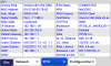
Is there any way to see what the name of the base station used is? If not, that would be a nice feature.
All the information available is shown in the RTN Source Table:
In the case a VRS, the generator uses multiple base station from the surrounding area to create the virtual base station.
Joe Paulin
Well-Known Member
It is possible to do this with the Triumph-LS and Triumph-2. Set up the base, make the Triumph-2 an external receiver on the Triumph-LS. Use your RTN profile to set the Triumph-LS to RTN corrections and collect the point. Then switch to UHF profile and turn off external receiver. Proceed with base rover setup.
Or you could put the LS on the base point with the RTN profile active, collect the point using RTN corrections, then set the base up on the point and start base rover.
Shawn, rereading this old post...how do you make the T2 an external receiver for the LS?
System>Connection Setup>Receiver Connection>External Receiver.
Make sure that the Triumph-2 has RTK v4 firmware installed. You won't be able to log raw data files with the Triumph-2 as external, but generally everything else should work.
Make sure that the Triumph-2 has RTK v4 firmware installed. You won't be able to log raw data files with the Triumph-2 as external, but generally everything else should work.
Joe Paulin
Well-Known Member
The firmware on my T-2 is 3.6.13, the latest stable version. I'm not sure what you mean by RTK v4??
The RTK4 firmware allows the Triumph-2 to use 6 RTK engines, otherwise your T2 will just operate as a rover with 1 engine which shouldn't be an issue if you are just using it to determine the base coordinate. RTK4 firmware can be download from http://www.javad.com/downloads/javadgnss/firmware/beta/GNSS/3_6_13b0_rtk4/
Joe Paulin
Well-Known Member
Thanks Matt. I didn't realize this was in beta still, I don't need to do it that bad... I was just rather curious. With the release versions of firmware and software in my units, I was able to connect the T2 as an external receiver but using ODOT VRS corrections, it wouldn't fix reliably. Eventually the LS locked up. I will wait for this stuff to be ironed out.