bad fix

David Held

New Member
I'm wondering if others have experienced bad RTK fixed positions utilizing the factory "boundary" settings. I'm talking about shots that have been through the entire validation, verification, etc. process utilizing the settings as they come from JAVAD.

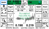
I'm working on a boundary retracement which includes several lines which have been surveyed a couple of times over the past 30 years and I had a bad RTK shot as described above on a monument where the record position based on two previous surveys is approximately 4' from the position I measured.

I'm utilizing a T2 base set in an open field about 3,000 feet from the site. The shot was in tough conditions and it appears that the fixed position from DPOS is pretty close to the previous surveys. Having the DPOS position is a great check on the RTK results, but in general, I've found the RTK results that go through the entire process as noted above are very reliable and certainly more so than the DPOS results. Any time I need to rely on DPOS for a shot, I will have redundant shots to verify the position.

I don't suppose JAVAD is still offering a pile of cash if you can get a bad fixed shot like this? On that note, does anybody know if that prize was ever actually won by some lucky (or unlucky) surveyor?

It's always good to have reminders that there's no substitute for checks on our work and I look forward to feedback from others on this.
 

Adam

Well-Known Member
5PLS
I use a minimum 240 seconds in my boundary profile. This is a personal opinion on that setting. You could use a shorter time and repeat. I have personally seen a bad fix last near three minutes. When I see one last near four minutes I will bump up to five.
 
Last edited:

David Held

New Member
I'm using J-field version 2.0.5.674. The boundary profile is set to 180 seconds after which the engines reset for the final verification.
 

David Held

New Member
Here's a screenshot of the accepted RTK point.
 

Attachments

  • 1031_20180119-21.52.39.png
    1031_20180119-21.52.39.png
    50.9 KB · Views: 368

Shawn Billings

Shawn Billings
5PLS
You need to update J-Field. The version you had was not properly applying Validate (the final reset and recheck of the fix). This can be seen by looking at the time on your screen shot. It shows 180 seconds. Validate should have added another 2-3 seconds minimum to the 180 seconds. It appears that the validate did occur, but the new fix did not agree with your current average. J-Field (in the version you have now) would pass the point as validated anyway.

You can read more about this here:

https://support.javad.com/index.php?threads/validate-is-broken.2836/
 

Shawn Billings

Shawn Billings
5PLS
No. The problem update (2.1.0.21) was removed and the previous version to it was made current release again, which is 2.0.5.1011. It is stable and addresses the Validate issue.
 

Nate The Surveyor

Well-Known Member
David,
There you go.
It's a real knot in the gut... To know that it lied...
But, it had ppk... (secondary backup system to catch the blunder)
I moved to pre release, (I don't have it in front of me now, to know the version) but, you would not have had the bad shot, without the bug in the software.
I think the link above should be better publicized.
You'll be in the green... Soon!
N
 

David Held

New Member
PPK is a great check for sure. Looking forward to getting back out to finish up this boundary when it's not pouring rain.
 

Duane Frymire

Active Member
PPK is a great check for sure. Looking forward to getting back out to finish up this boundary when it's not pouring rain.
Ah ha, must have missed that thread about verification not working in a certain release. Guess I need to send another email out to upgrade software. Don't rely on RTK or DPOS if they are not in close agreement, that's part of the process. In other words, you should have known you had a bad position even if you didn't have a known coordinate from before. So no prize for you, the system worked, even when it was broken:)
 

Darren Clemons

Well-Known Member
Glad you caught the rtk error David. The PPK backup is SO valuable in this Javad system. It has saved our butts numerous times. Reading what you had happen made me think of something we do that is another great way to catch/check potential rtk blunders.

When we work with previous surveys, as you are describing, we never go to the field without having our parent deed as well as any surveyed adjoining deeds “punched in” and then take calculated design points with us. We use seamless imagery with world files in cadd where we can literally have the points all around our lot/farm usually within a few feet of their actual location before even starting the base! (Shawn Billings has a great YouTube video about this as well). It doesn’t seem however that many people do this. It makes thing so, so much quicker. Of course, the main issue is that it always depends on the quality of the survey you’re trying to follow.

In the example you describe above, if we had, say, 8 survey corners and had tied into the first three or four (preferably out in better/open areas) and they checked well we would do a move and then a rotate (some do localization but I hugely prefer move/rotate - localizations are tremendous if there’s literally NO error but there’s very few surveys I follow that don’t have a little to a lot of traverse error) to the best two with our batch of design points, thereby giving us a coordinate to stake to on the “tough” point you received a “bad” rtk on. If say, you’d adjusted and all points so far were hitting very well (and especially if you knew the surveyor who had done the previous work), then you’d have a very good idea of the expected accuracy of the point you are trying to collect.

If everything you’d collected on the previous survey so far was hitting at 0.1’ to 0.7’ or similar and then after storing that rtk shot you got 4’ inversing from your “design” point and “survey” point you’d have a pretty good idea immediately that something was up. I actually “collect” in stake mode most times in this scenario and if my DTT (distance to target) was showing me 4’, I’d KNOW it was “stuck” on a bad fix. Depending on the time the session was up to, I’d do one of two things. If it was close to 15+ minutes I’d let it continue, store the PPK, then immediately start another session. If it hadn’t had much time stored, I’d just stop, reject, reset rtk and reset tracking and start all over.

If your retracing a good/very good existing survey, calculated design points are worth their weight in gold!!
 
Top