Phillip Lancaster
Active Member
Look at the overall RMS.
Look at the overall RMS.
I'm not permitted to attach the file here in the forum, sorry Alexey. Could the Administrator of the forum increase the allowable file size for attachments?
I've created a folder on DropBox: JAVAD GNSS wherein I placed the file.
https://www.dropbox.com/s/wkc2jdg7pwzwahx/FHC-02_092649.jps?dl=0
Let me know if you have issues downloading and I'll address them upon my return to the office tonight or tomorrow morning.
Thanks! Got FHC-02_092649.jps.
I asked an Administrator but he refused.
Interesting observations, though, to be honest, I'm not sure what to draw from them without NGS allowing GLONASS, or DPOS allowing the exclusion of GLONASS.
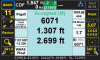
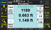
I didn't catch on earlier that it was at the coast. How is the Cors geometry, especially to to the East?@Alexey Razumovsky I know this keeps coming up, and for the most part its not an issue, but I just did a project on the coast of NC. Ran a 3 hour static session on one point, and a 90 min session on another point. Also tied both points using the NC RTN. I know sometimes the Verticle with the RTN, is suspect, but thought I could use them just for a check. I ran both the static sessions through DPOS and OPUS. The 3 hour static session processed from OPUS an DPOS was within 0.05'. I felt that was acceptable. just hold the DPOS solution. Ran the 90 minute static session through both as well. The Difference was a little alarming. The difference is 0.20'. I had to run a level through several monitoring wells, so thought I would run the level between the 2 static sessions, to make sure all is well. After running 7K' of Level Loop, closure on the loop was 0.0032', gotta love a Leica Digital LS10 level.
The two OPUS solutions fit the level loop within 0.029' The DPOS solutions misses the level loop by 0.145' That is the reason for my post. In this situation, If I had not ran the level through the points, I would not know which point is good enough to publish. I would probably accepted the DPOS solution on the 90 minute session and not thought anything about it, but when the DPOS solutions did not fit the level loop, I decided to see if OPUS agreed with the DPOS solutions, and they are close on the 3 hour session, and differ greatly by the 90 minute sessions.
Is this something that we need to be concerned with? Was it an anomaly? Is there a rule of thumb on a session that is less than 2 hours?
I have attached a spreadsheet showing the differences. I can produce the files if further investigation is necessary.
Thx
I have attached a spreadsheet showing the differences. I can produce the files if further investigation is necessary.
I decided to see if OPUS agreed with the DPOS solutions, and they are close on the 3 hour session, and differ greatly by the 90 minute sessions.
24 hours in my opinion. I settle for 4 to 8 hours most every day.what is the minimum for obtaining a rock solid elevation.
Recently I had multiple (5 or 6) hour an half observations with varying receivers ( T2 and LS )with several different rod combinations and even zero rod observations that disagreed by some .4 ft. I then ran long static sessions, two of them with 7 to 8 hours each. They agreed within .03'. My opinion is long base session and Rtk of 3 to 4 minutes x2 will yeild the best vertical solutions you can get without running 7 or 8 hour static on each point.It's been my experience that 90 minutes isn't really long enough to obtain the elevation accuracy that you are looking for, no matter which processing service is used. Perhaps in this case, the OPUS solution that agreed was just coincidence.