Exporting Points with Attributes

Joe Paulin

Well-Known Member
This topic is really more of a CAD topic. I am interested in hearing how everyone is exporting survey points and bringing them into their CAD program so that all of the attributes show up in a nice clean format. For a lot of my surveyed points, I take advantage of JField's coding and attribute capability to document conditions of points, for example boundary monuments. Typically the point description is left blank and all the monument data is stored as code attributes. I have been exporting a PNEZD .csv point file (with my description being the code followed by all the attributes) out of JField and importing it into my CAD program (I use Civil 3D 2013 for better or worse). A typical boundary point in CAD would then look like this:

upload_2017-10-5_10-55-25.png


This of course works but isn't optimal, especially when points are close together such as below:

upload_2017-10-5_10-57-11.png

Pretty hard to read the attributes here. I can change the scale of the points to make them smaller and this is what I normally do.

I should stop and note that my CAD skills are poor, especially with Civil 3D.

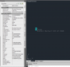
I started playing with different ways to export things in JField and came across the .dwg option. When I export the points as a .dwg, it creates a .dwg with the points as blocks. What is great about this is that all of the coding and attributes and much much more about the surveyed point is displayed as properties of that block when it is selected. Here is an example:

upload_2017-10-5_11-7-13.png


Look at all that point metadata! The problem is that these are blocks, not autocad points. I don't know if there is a way to convert these blocks into points and still retain all of the attributes and metadata. It would be very advantageous to be able to see this data when a point is selected in CAD. Is there a way to do this? What are others doing to be able to conveniently view attributes and metadata of autocad points?

Thank you for your thoughts & input.
 

Joe Paulin

Well-Known Member
Thanks for the reference, but unfortunately, this procedure would strip all the attributes away from the point when converting. I would be better off just inserting a standard point file into CAD. My main goal here is to see if it is possible to create CAD points that have all the attributes and metadata as seen above attached. J-Field stores an incredible amount of information with it's surveyed points (codes, attributes, gnss solution info, precisions, etc) that I would like to see in CAD as well.
 

John Evers

Well-Known Member
5PLS
Joe,

I have been doing what you do.

I manually change all of the dwg imported point blocks to a common layer that is normally frozen. I love the wealth of information.

I import my text file, and let my old version of LDD insert the symbols, and build the cadd point database. I don't think there is a nice way to clean up the long string of text on a point. When I actually need to read it, I use the edit point command in LDD to display the text.
 

Joe Paulin

Well-Known Member
Oh this is good stuff, I just figured it out... use the LandXML export option in JField and then import that LandXML file into Civil 3D. You will get Civil 3D points with all the JField attributes and metadata listed in the point properties. It's a bit more complicated than that, if anyone is interested in this let me know and I can go through the procedure step by step. This will make things a lot easier... here is what I now see on screen: point number, elevation, code & point description (if any). Selecting the point displays full attributes and metadata for each point in the properties box. Just what I wanted:):)

upload_2017-10-5_14-59-3.png
 

Attachments

  • upload_2017-10-5_14-56-39.png
    upload_2017-10-5_14-56-39.png
    81.7 KB · Views: 271

John Thompson

Well-Known Member
It's a bit more complicated than that, if anyone is interested in this let me know and I can go through the procedure step by step.
I tried importing points into Carlson Survey via LandXML and I don't get any of the metadata you show. Just point names/numbers, elevation, and a description that is the concatenation of code and attributes.
 

John Evers

Well-Known Member
5PLS
Joe,

You have shown me the first bit of functionality that C3D has over LDD.

Almost enough to consider jumping on the C3D crazy train.
 

Joe Paulin

Well-Known Member
As you can see, with this metadata in CAD one can see all the rtk parameters used to obtain that point. Before I would have to break out the LS to look at this stuff if I couldn't recall. "What was the HMRS of that point? How many epochs did we collect on it?" Now you can click on the point in CAD and tell very quickly. I really don't know if anybody else has been already doing this, but I was very happy when I got it to work.
 

Joe Paulin

Well-Known Member
All right, here is what I did, using Civil 3D 2013:

  1. Export a Land XML file of your project out of the LS.
  2. In Civil 3D, create a drawing however you normally would.
  3. In the Survey tab of the Toolspace, create a new Survey Database by right clicking Survey Databases and selecting New local survey database.
    upload_2017-10-6_8-14-16.png
  4. With your survey database created, right click it and select Edit survey database settings.
  5. Change your units and coordinate zone as you see fit and scroll all the down to the bottom of the settings and check the box for Create new definitions automatically. Then hit ok and close the settings box. This is the key step in getting the attributes and metadata to show up in the point properties.
    upload_2017-10-6_8-36-58.png
  6. Right click on Import Events and select Import survey data. Make sure your survey database is selected and then click next. Change the data source type to LandXML file and select your LandXML file your exported out of your LS. Then click next.
    upload_2017-10-6_8-41-34.png
Review the import options and make sure Insert survey points box is checked. Click Finish and the points will be inserted into your drawing.
upload_2017-10-6_8-59-15.png
You might need to change your point label style to suit your preferences. Here I have it set to display point number, elevation and description. The description is actually the JField code followed by any point description I entered when I shot the point. In Civil 3D, you can set the point label style to display anything you want from all of the attributes and metadata of the point. After selecting the point and opening the properties box, here is an example of what it looks like - please note that you have to scroll down in the properties box to see all the metadata:
upload_2017-10-6_8-59-48.png
Here is a pin that was bent, but the base of the pin was stable and I was able to spin the pin and shoot the location of the base. All of this conditions are captured here. Looking at this now, it appears that the attributes and metadata are scrambled all out of order in my screenshot above...so I still have some work to do to figure this out. Yesterday they were ordered and grouped together somewhat.

This turned into a long post but hopefully this will be of some benefit to others.
 

Matt Johnson

Well-Known Member
5PLS
I will outline my procedure here tomorrow for all to see. This is for Civil 3D, but hopefully LDD and Carlson has similar procedures for those that use them.

I believe Carlson only supports point attributes if you have the GIS module. I have Civil 2011 without the GIS module and point attributes are not supported. You can always do as John described though and import the point blocks from a dwg file and then import the points into the coordinate file from a text file.
 

Adam

Well-Known Member
5PLS
I believe Carlson only supports point attributes if you have the GIS module. I have Civil 2011 without the GIS module and point attributes are not supported. You can always do as John described though and import the point blocks from a dwg file and then import the points into the coordinate file from a text file.
Point attributes can be used in Carlson Survey if you set it up under the GIS tab. You don't have to have the full blown GIS module. It has been a few years since I used attributes in Carlson. It reads a .vtt file witch is just a text file.
 
Top