Thomas Campbell
New Member
On our LS, After we collect a new Trajectory, a line now also appears that connects the Base position to the first point on the trajectory. This was not the case in the past. I used the unit on 8/25/20 and it did not do this, but it does it now.
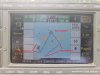
I have attached a picture of the screen from some testing we did here at the office.
I have identified the ends of two trajectories with red text and lines and then have a orange arrow pointing to the lines that are drawn to the base.
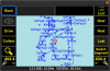
It gets a bit stranger when you open an older project that has been DPOSed and that is how we discovered the issue. When you open an existing project, each trajectory has a line from the fist point to the base, the last point to the base, a line from the first point to the last point and the trajectory object itself is duplicated. Possibly showing the trajectory at the initial position and then at the new rectified position after DPOS.
This is a major issue for us. We use the unit to collection golf irrigation components to create record drawings. We use the trajectory option to collect pipe and wire routing. So there can be numerous trajectories and points. The screen is very confusing to view now.
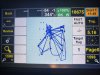
I have also attached a shot of an old project that will show how confusing it is. This is a very simple poject with only 28 trajectories, some of our projects have hundreds of trajectories.
Everything exports correctly, these base connect lines do not show in the export.
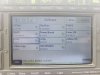
I have also attach a picture of the software version screen for reference.
We have looked all over to perhaps find an option to turn off the line's display, but have not found a way.
Any thought on how to remove these lines?
Thanks
I have attached a picture of the screen from some testing we did here at the office.
I have identified the ends of two trajectories with red text and lines and then have a orange arrow pointing to the lines that are drawn to the base.
It gets a bit stranger when you open an older project that has been DPOSed and that is how we discovered the issue. When you open an existing project, each trajectory has a line from the fist point to the base, the last point to the base, a line from the first point to the last point and the trajectory object itself is duplicated. Possibly showing the trajectory at the initial position and then at the new rectified position after DPOS.
This is a major issue for us. We use the unit to collection golf irrigation components to create record drawings. We use the trajectory option to collect pipe and wire routing. So there can be numerous trajectories and points. The screen is very confusing to view now.
I have also attached a shot of an old project that will show how confusing it is. This is a very simple poject with only 28 trajectories, some of our projects have hundreds of trajectories.
Everything exports correctly, these base connect lines do not show in the export.
I have also attach a picture of the software version screen for reference.
We have looked all over to perhaps find an option to turn off the line's display, but have not found a way.
Any thought on how to remove these lines?
Thanks