Nistorescu Sorin
Active Member
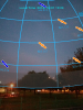
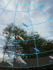
Is it possible to implement such augmented reality for existing satellites, in JMT? Nice to see GPS GLONASS, BeiDou, Galileo, and SBAS from the current location through the camera’s viewfinder.
The satellite placements are calculated based on publicly available orbital information from the North American Aerospace Defense Command (NORAD).
The satellite placements are calculated based on publicly available orbital information from the North American Aerospace Defense Command (NORAD).