Rover points shot from RTN currently do not process with a base that is running simultaneously. I don't think this issue has been addressed yet. But I do think we should allow for RTN users to also be able to post process in DPOS using a Javad base as Aaron describes.
You are using an out of date browser. It may not display this or other websites correctly.
You should upgrade or use an alternative browser.
You should upgrade or use an alternative browser.
Unusual DPOS Results
- Thread starter Aaron S
- Start date
He is trying to process points collected with his base profile to check RTN points.
Aaron S
Active Member
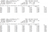
What is the difference between RTK-BCP and PPK-BCP? In the attached screenshot, the difference between the two is only a few hundredths. If I'm receiving realtime corrections from the base station, I thought the rover points would be effectively tied to the base and move around with it. Doesn't PPK only apply if there is no realtime link?
Attachments

Doesn't PPK only apply if there is no realtime link?
No, points can have both RTK and post proccessed solutions.
Duane Frymire
Active Member
The RTK solution is filtering out data real time, the ppk (pps really as matt pointed out) is taking all the data collected and filtering after the fact using differing algorithms. In both cases the solution is depending on the static/rapid static (for lack of better terms) position of the local base (BCP). But you can have a third solution that will give you a position independent of the local base. In DPOS settings (the gear looking icon) you can select to also show a cors post processed solution. You might want to do that if you have cors stations that are close, or if you are doing a relatively short base occupation on an unknown coordinate. When you look at the points you will know because you will not see BCP; I can't remember what you see instead (PPK-COR maybe?). I have tried this just to see how things look, and get a few centimeters difference; but that's why I don't use it much because the nearest cors is usually 25 miles away so the local base is better reference (as long as occupation time and base location are reasonable).What is the difference between RTK-BCP and PPK-BCP? In the attached screenshot, the difference between the two is only a few hundredths. If I'm receiving realtime corrections from the base station, I thought the rover points would be effectively tied to the base and move around with it. Doesn't PPK only apply if there is no realtime link?
Aaron S
Active Member
Here's another one that (I think) turned out great, even though it shouldn't have. I shot this one almost a year ago, under moderately dense canopy. I could only get a single epoch after sitting on the point for 20 minutes and my intent was to come back later with a local base to get it. At the time, I submitted the raw file to OPUS, and got terrible results. Back then, I was fairly new to all of this.
Yesterday, I was trying to remember what info I was able to get on that point and just to jog my memory, I sent it to DPOS instead of OPUS as a standalone solution. Check out the attached report, that's pretty good right? It's so impressive what the DPOS system can do that other systems can't.
Yesterday, I was trying to remember what info I was able to get on that point and just to jog my memory, I sent it to DPOS instead of OPUS as a standalone solution. Check out the attached report, that's pretty good right? It's so impressive what the DPOS system can do that other systems can't.
Attachments
Everything goes well.Here's another one that (I think) turned out great, even though it shouldn't have. I shot this one almost a year ago, under moderately dense canopy. I could only get a single epoch after sitting on the point for 20 minutes and my intent was to come back later with a local base to get it. At the time, I submitted the raw file to OPUS, and got terrible results. Back then, I was fairly new to all of this.
Yesterday, I was trying to remember what info I was able to get on that point and just to jog my memory, I sent it to DPOS instead of OPUS as a standalone solution. Check out the attached report, that's pretty good right? It's so impressive what the DPOS system can do that other systems can't.
Duane Frymire
Active Member
I would send it to OPUS again now, just for curiosity sake. I've found DPOS to be better as well, but usually there's not a situation where one is really terrible and the other really great. I've read that sometimes a particular CORS will have a problem for a time and you can remove it from the solution until they get it fixed. I wonder if this is what happened on your first OPUS submission. Or look at your original OPUS solution and see if there is one station that is way out and affecting the results. OPUS rapid static will use up to 9 and might have included one too far away that screwed things up as well.Here's another one that (I think) turned out great, even though it shouldn't have. I shot this one almost a year ago, under moderately dense canopy. I could only get a single epoch after sitting on the point for 20 minutes and my intent was to come back later with a local base to get it. At the time, I submitted the raw file to OPUS, and got terrible results. Back then, I was fairly new to all of this.
Yesterday, I was trying to remember what info I was able to get on that point and just to jog my memory, I sent it to DPOS instead of OPUS as a standalone solution. Check out the attached report, that's pretty good right? It's so impressive what the DPOS system can do that other systems can't.
Quality indicators DPOS - rms less than 3 cm, dop less than 2
Quality indicators OPUS-RS - rms less than 3 cm, obs used greater than 50% (I like greater than 70%), normalized rms less than or equal to 1
But, OPUS-RS may have a problem with NERRS stations, one of which looks to be in the Duluth area, and I notice you are in MN. Try excluding that station if your OPUS-RS was including it.
Last edited:
I find low 'Residuals of Position" from all the CORS stations to be the best indicator of a good solution.

Note that with OPUS these are only shown in the extended report.
Note that with OPUS these are only shown in the extended report.
Aaron S
Active Member
So I tried sending it back to OPUS as-is and it came back with the first group in the attached pic (I just took what I thought were the relevant portions of the report). The results were quite bad, but I saw that it selected a bizarre group of stations to use - one in another state.
I send it a second time, but told it to include the 4 stations that DPOS used and exclude all the others. Well it still obliviously crammed in a bunch more stations to fill the void, and the results were bad again. It seems to have a problem figuring out which stations to process from.
Not that I care so much about using OPUS ever again, but it's still kind of curious.
Attachments
Aaron S
Active Member
So a couple days ago, I set up the base with no radio link, and no intention of doing RTK (DPOS only). The canopy was extremely thick, and I let the LS set for maybe 15 minutes, thinking that would be enough to process DPOS later. The results of that particular point (#329 in the attached) show a float solution. Does that mean I should have let it set for a longer time? The point details says it has 900 epochs, which is normally enough, so I don't know why it wouldn't work, other than too much canopy and not enough time.


I think not enough time for the conditions. Sometimes 15 minutes will yeild a good solution in thick stuff but not always. You may need as much as thirty minutes or even an hour. And there's no way to know your right with just one static solution even if it returns a fix.So a couple days ago, I set up the base with no radio link, and no intention of doing RTK (DPOS only). The canopy was extremely thick, and I let the LS set for maybe 15 minutes, thinking that would be enough to process DPOS later. The results of that particular point (#329 in the attached) show a float solution. Does that mean I should have let it set for a longer time? The point details says it has 900 epochs, which is normally enough, so I don't know why it wouldn't work, other than too much canopy and not enough time.
View attachment 7491View attachment 7492