Jim Frame
Well-Known Member
Yesterday I ran a 30-minute rapid-static session on a couple of points, and just for fun decided to see if I could get RTN (single-base) positions on them. The base was about 30 miles away, so I knew I was pushing the envelope way beyond the point of reliability, but I wanted to see what would happen.
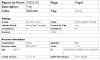
I shot point 1 before the static session, and got 3 engines fixed and decent stats. I was surprised it fixed at all, but thought "Hey, great!" The counter stalled at 139 epochs and I didn't want to wait around, so I just called it good and stored the point. Here's a screenshot of the point info:

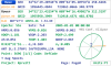
After breaking down the static session, I fired up the LS again and re-shot point 1 for about a minute, then shot it again for another minute. I inversed from the first shot and was dismayed to see that it differed from the last two by over 7 feet horizontal and 4 feet vertical. Here are the screenshots from the last two:


The two 1-minute shots are very close to the OPUS-RS position (sans rapid orbit) I got on the point.
My question isn't "How do I get reliable positions at this distance," but rather "Is there anything in the stats that I should have seen to indicate that the position I was getting the first time was bad?" Did I overlook something, or is this just the level of unreliability to be expected when exceeding recommended distance limits?
Thanks!
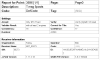
I shot point 1 before the static session, and got 3 engines fixed and decent stats. I was surprised it fixed at all, but thought "Hey, great!" The counter stalled at 139 epochs and I didn't want to wait around, so I just called it good and stored the point. Here's a screenshot of the point info:
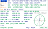
After breaking down the static session, I fired up the LS again and re-shot point 1 for about a minute, then shot it again for another minute. I inversed from the first shot and was dismayed to see that it differed from the last two by over 7 feet horizontal and 4 feet vertical. Here are the screenshots from the last two:
The two 1-minute shots are very close to the OPUS-RS position (sans rapid orbit) I got on the point.
My question isn't "How do I get reliable positions at this distance," but rather "Is there anything in the stats that I should have seen to indicate that the position I was getting the first time was bad?" Did I overlook something, or is this just the level of unreliability to be expected when exceeding recommended distance limits?
Thanks!