Android style

Nistorescu Sorin

Active Member
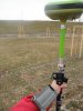
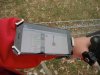
For the moment, I made some minor changes to Android style for my old GNSS receiver.

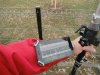
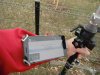
Ingredients: Javad graduated monopod, 6000mAh Android phone, DJI phone bracket, "anti-text neck" adaptor, etc. The best of all is Triumph-1 which shows a 4-parallel RTK engines in JMT. This is state-of-the-art, for a 10 years receiver.

But everything could change fast..

PS: JMT screen settings are for test only.
 

Attachments

  • monopod.JPG
    monopod.JPG
    3 MB · Views: 514
  • zoom 1.JPG
    zoom 1.JPG
    3.2 MB · Views: 520
  • zoom 2.JPG
    zoom 2.JPG
    3.1 MB · Views: 511

Nistorescu Sorin

Active Member
At the end of the year, during a static session (with JMT aid), can still find room for reading..
;)
 

Attachments

  • Pinpoint.png
    Pinpoint.png
    155.8 KB · Views: 465

Nistorescu Sorin

Active Member
Trying to make JMT for Android wearable at -10 degrees. There are four RTK engines with the "verify" checked. I tried 5Hz upsampling, but lost the fixes, so I gave up.

Still need some velcro reinforcements for the bracket, for more testing.
 

Attachments

  • p1.JPG
    p1.JPG
    3.2 MB · Views: 554
  • p2.JPG
    p2.JPG
    3.2 MB · Views: 543
  • p3.JPG
    p3.JPG
    3.2 MB · Views: 525
  • p5.JPG
    p5.JPG
    3.2 MB · Views: 523
  • p7.JPG
    p7.JPG
    3.1 MB · Views: 587

Zoltan Varga

General Manager of Geomentor Kft
What is the exact type of the phone holder ? Can you give a link to the webshop ? Is it fixed to the pole or to your arm ?
 

Nistorescu Sorin

Active Member
Taking a quick look at TyrAnt G2T antenna, then at T2 receiver:

TyrAnt G2T with L1/L2/L2C/L5, Galileo E1/E5A is very attractive, but no batteries, Wi-Fi, Bluetooth and integrated Compass/Inclinometers.
Anyway I like it's size (140.4 x140.4 x 62.2 mm).

T2 has many great functionalities but no Galileo E1/E5A, and as far as I know there is no sign of interference protection / built-in ionospheric robustness (very important especially when acting as a base).
Also I like it's size (85 x 61 x 132 mm)

About the receiver options I must say that no one will buy a receiver without Beidou and Galileo, so probably must include them as a standard configuration. I will understand that each of these devices has it's different role, but I still imagine such a small receiver which could combine T2 / TyrAnt G2T functionalities, that can be used with JMT.
 

Nistorescu Sorin

Active Member
The phone as we know it will evolve fast into a great tool, that could:
- bring augmented reality at home and in the field;

- collaborate to produce 3D models of the real world;

- display Galileo PRS-assured positions on a map, using a state-of-the-art server-PRS distribution approach and by attaching a small module to the phone (this is an erratum for the link at #9); other than police, government and emergency services, some large contractors could have access to Galileo PRS;
http://nsl.eu.com/nsl-jcms/about-nsl/nsl-blog/12-company-news/51-grippa-eusatnav

- use raw GNSS measurements (L1 for the moment) and external RTCM streams for orbit/clock corrections, such as the ones available from the International GNSS Service Real-Time Service, to compute the precise position of the phone in real time (PPP), with very high level algorithms (developed by the French Space Agency), proving that it is only a matter of time before our smartphones can provide cm-level positioning accuracies;
https://play.google.com/store/apps/details?id=jocs.fr.gnss_ppp;

The only thing I have to do is to adapt.
 

Nistorescu Sorin

Active Member
Together with a GNSS sensor, my phone tends to become a standard surveying tool. With access to a of uniformly distributed GNSS receivers network across country and a low distortion projection (LDP implemented but still in development), the surveyor can afford a minimalist style (very cost-effective) in terms of equipment in use (phone-receiver).

As part of this inexpensive solution, JMT will be very attractive due to its ongoing development functions. So, configuring the receiver, calibrating, measuring with statistics, staking, (J-Field-like) reporting(!) and many other functions, are now possible. That's why I would like to emphasize the effort of the entire team that develops this useful Android software.

J-Field style JMT report.png


Anyway, there are some tools that a surveyor would need in the field with JMT:
- the ability to convert vertices from imported polyline(s) into design points;
- show the point number/description/height on the map (not only by tapping the point);
- select/deselect satellites for position computation - individual or the whole system;
- intuitive planning and if possible ionosphere monitoring tools (ex: https://play.google.com/store/apps/details?id=com.swepos.jono);

By the way, from the above test, the calculated distance between 501-502 RTK points each with 25 epochs (verify/reset option enabled) is RTK HD=65.383m; with TS we obtained TS HD=65.379m; NRTK solution, open sky, 4 RTK engines fixed up to 10km from master GNSS reference station, MAC_3.1_GG correction used.
 

Nistorescu Sorin

Active Member
Also JMT could be suitable for receive data from total stations within Bluetooth connection . Easy changing (for raw/points data collecting) between GNSS receiver or total station, through a JMT interface, on the same screen with the Android rugged device, is what I need in the field.
 

Nistorescu Sorin

Active Member
Somehow we are encouraged to push our smartphones limits.
https://www.gsc-europa.eu/news/gnss-raw-measurements-set-to-be-a-game-changer

I admit it's very useful to use the phone for navigation purposes, but to find a coordinate (for the moment) with decimeter precision, only with the phone, will rise many questions.

The guys from Geo++ are deep involved into this subject:
https://play.google.com/store/apps/details?id=de.geopp.rinexlogger

When Broadcom announced the BCM47755 receiver with expanded availability of L1/E1 and L5/E5 frequencies in satellite constellations, I realized that centimeter-level accuracy with smartphones is imminent.
https://www.gsc-europa.eu/news/broa...-dual-frequency-gnss-receiver-for-smartphones

Although there are so many differences from a geodetic receiver, I could not resist to obtain a RINEX from a smartphone, for post processing.

IMG_20171022_184126.jpg


IMG_20171022_184158.jpg


Now I must change my phone..
 

Nistorescu Sorin

Active Member
Usually, in the field I open some dwg/dxf files with GnaCAD (for Android);
https://play.google.com/store/apps/details?id=com.gna.cad

It has the ability to work with very large files on my android phone, both 2D and 3D drawings and it is able to insert raster image from file. When using a larger tablet and a mouse it becomes like a (Android) desktop for CAD, in my opinion.

But for some reasons, when I'm trying to import a simple DXF file from JMT to GnaCAD, I get the message: "LAYER table duplicated". And JMT crashes when I want to import a DXF file from GnaCAD. Any suggestion?
 

Nistorescu Sorin

Active Member
Thank you Matt for the answer. No problem to attach any DXF file, but I think Yuri will simply try to install GnaCAD and test import/export in both directions, if possible.
 

Nistorescu Sorin

Active Member
I use a small bracket to attach a waterproof phone case onto my pole.

T1+bracket.png


After a long day in the rain with many stakeout points, I can say that the light green color is not the best solution for any kind of eyes. No problem when the text color is black, just when become light green, in the proximity of the point. Maybe some kind of a solid green color for the text indicated by the arrow.

T1+waterproof case.png


Thanks.
 

Nistorescu Sorin

Active Member
Among other sensors, a smartphone will have a built-in optical laser (with rangefinder) to determine distances up to 10 meters for the moment. Probably a back-end server will scale the whole picture, to help us making some area calculation, etc.


Maybe a good ideea for Victor LS.
 
Top