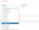
Via the WEB Browser, make sure to select in Network, CORS(US) or Oregon(US) or Washington(US) or Texas(US) for North America processing accordingly...Tried Web Browser and failed, no cors in range.
You are using an out of date browser. It may not display this or other websites correctly.
You should upgrade or use an alternative browser.
You should upgrade or use an alternative browser.
Justin down?
- Thread starter ken larson
- Start date
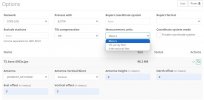
From the DPOS Processing WEB interface, select OPTIONS and then you can select the Measurement Units to use in the post-processing report.The website kicked back a processed data report finally, but it is not much use to me...it is metric, lats and longs...I am going to have to wait and hope it gets resolved soon.
In addition, you can select the Antenna 'type' and also add the antenna 'offsets' used.
Attachments
ken larson
Active Member
Thanx for trying John, but this is all a new end of round for me. I have no clue where to find that options page.....my prior procedure was to dpos with the LS+ and that was it.
avoidthelloyd
Active Member
DPOS is one of the main features that sets Javad apart from the competition. I told a salesman of another brand that I could get my raw data processed through CORS with a click and he literally didn't believe me and said "that can't be done".
But... I had to go back 7 years and use OPUS... dang it.

But... I had to go back 7 years and use OPUS... dang it.
avoidthelloyd
Active Member
Justin online is hanging up also.

Mark Wheeler
Active Member
Can Anyone from JAVAD provide an update or atleast an indication that the issue is being seriously addressed?
ken larson
Active Member
Yeah....just let a file from Tuesday run for hours and it failed....no cors in range
I believe the definition for insanity is doing the same thing over and over again and expecting different results. As Mark Wheeler asks, it would be nice to know where we stand. I know we have been spoiled by this stuff, but we also rely on it as a way to do our job to the best of our ability. If we have to reconfigure our work flow, I hope we can all help each other learn a different approach. (Hint, hint). I am not the sharpest knife in the drawer but I am willing learn a new way if we do indeed lose this valuable asset. Mike
avoidthelloyd
Active Member
I currently have 3 projects hung up while I wait for this to be fixed. I really needed to finish one today. @Matt Sibole @John Rosco Are the engineers looking at this? ETA?
Harold Dendy
Member
10:15 pm Friday night Central. 40% done importing data, and stopped. This morning, I got the no CORS data message. I hope they get this up and running soon. I have a job that really needs DPOS.
Same here. Tried DPOS thru LS again a little while ago. 40% done. Tried the Web processing (not knowing really what I was doing for first time) 1 1/2 hour later. No Cors in Range. Tell me it is down and not going to be resolved and operational and I will figure another procedure to accomplish my tasks. Just leave us all hanging. Time to go to bed.
I give up. After trying DPOS thru LS and getting 40% over and over and using the Web based DPOS and getting NO CORS IN RANGE God knows how many times. What are you guys going to use as your alternative method if you don't mind sharing. It is a shame that something Shawn once called an elegant process (I believe I remember him posting long ago) has evidently been kicked to the curb.. Any help or thoughts would be greatly appreciated. Mike
avoidthelloyd
Active Member
Same results this morning. 
@Michael You can export your Archive file and extract it. Inside there, under SD, will be your base file you downloaded. Its a .jps file type. Just take it and your HI and go to https://www.ngs.noaa.gov/OPUS/ like we used to have to do it. Select your file and the antenna type (Triumph-3, T1M, etc.) and height (in meters). It will email you the solution in a handful of minutes. Near the bottom of the report will be State Plane Coordinates in meters, so get your calculator ready. The ORTHO HGT is your elevation in meters.

@Michael You can export your Archive file and extract it. Inside there, under SD, will be your base file you downloaded. Its a .jps file type. Just take it and your HI and go to https://www.ngs.noaa.gov/OPUS/ like we used to have to do it. Select your file and the antenna type (Triumph-3, T1M, etc.) and height (in meters). It will email you the solution in a handful of minutes. Near the bottom of the report will be State Plane Coordinates in meters, so get your calculator ready. The ORTHO HGT is your elevation in meters.
Harold Dendy
Member
“Me, too.”
I collected some points in autonomous mode out of range of UHF and no cellular network signal that need a DPOS solution. I am spoiled as to the ease of use of DPOS, its convenience, and the translation of a base point to a better or average solution, bringing all related points to the new adjustment. The ability to select the apparent better of an RTK or RTPK collected point Is a great tool. I miss DPOS.
I really need to know if this is going to be fixed and when. My workflow and methods of data manipulation will have to undergo some serious changes if this continues. Come on, JAVAD. Help us out, and provide some answers.
Nate The Surveyor
Well-Known Member
Harold, Try this:
Points.
Go up or down and FIND this particular point. Highlight it.
Find 3 bar button in NW corner screen Press that.
Look at bottom of screen. It says CLOSE. Just to the RIGHT of this is an arrow button like this: >> Hit the >> twice.
Second bar down, on your left, is a button. "Post Process Selected Point".
Press this.
This will USE the DOWNLOADED base file, to Process against the Sideshot from base, that did not have enough radio to "RTPK". This will give you a POST PROCESSED RTPK value.
I hope this can help you.
Nate
Dear Customers,
We are aware of the interruption of the free DPOS service, and our team is working diligently to restore the operation.
There will be an announcement when DPOS service is restored.
Meanwhile, free post-processing may be accessed from OPUS at https://geodesy.noaa.gov/OPUS/.
JAVAD GNSS Inc
We are aware of the interruption of the free DPOS service, and our team is working diligently to restore the operation.
There will be an announcement when DPOS service is restored.
Meanwhile, free post-processing may be accessed from OPUS at https://geodesy.noaa.gov/OPUS/.
JAVAD GNSS Inc
Ron Cloninger
Member
Wonderful, Thank You to everyone working on this.