briarcutter
Member
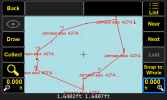
Couple months ago I updated my LS+ to the 4.0 software ... since then when I import my local files (10,000/10,000) to the LS the points are inverted.
They are imported into a Page with WGS84(ITRF2008) as the crd system
The attached pdf is the "true" plotting of the points and the attached screen shot is their orientation after import
Any help is appreciated ... thanks in advance
Paul
They are imported into a Page with WGS84(ITRF2008) as the crd system
The attached pdf is the "true" plotting of the points and the attached screen shot is their orientation after import
Any help is appreciated ... thanks in advance
Paul