Dpos still messes up localize.

Nate The Surveyor

Well-Known Member
If I go to the field, localize on an older project, Return to office, and dpos it, the coordinates of the local system MOVE the same amount as the DPOS shift.

I have had to keep a close watch on this. And, often, AFTER DPOS, I have to delete the local coords, and all the localize, and, all remains of the localize, then, SET spc current, and start over.

I would like it, if the local coordinates did not shift, when dpos MOVES or SHIFTS the underlying SPC coords.

Nate
 

Nate The Surveyor

Well-Known Member
Another thing, with the current version, is it is now refusing to update the coords, that are on PAGE 1, (Page 1 is the field localize) So, either I HAVE to change all coords to be on page 0, or I can SET page 0 and Page 1 to SPC, and start another page, as "Unknown" and re-import the local coords. Maybe that will work. It's supposed to "Recompute Localize". But, it's not working right.

N
 

Nate The Surveyor

Well-Known Member
No, it does not recompute localize.

So, I tried to work around.

I deleted all design coords, and cleaned up the LS, ie, purged all of the prev localize.

Then, tried again.
HOWEVER some of the coords, are on Page 0, and some are on Page 1. Page 1 is localized.
The coords on page 0 and the ones on page 1 are not being handled the same.

So, It looks like I have 2 solutions. Either change all survey points to be on page 0, and start over.
OR
Leave the coords, on Page 0, and Page 1

And Purge, and delete all localize. And, start over, with local coords, on PAGE 2.
Re-importing them.
N
 

Vladimir Prasolov

Well-Known Member
JAVAD GNSS
No, it does not recompute localize.

So, I tried to work around.

I deleted all design coords, and cleaned up the LS, ie, purged all of the prev localize.

Then, tried again.
HOWEVER some of the coords, are on Page 0, and some are on Page 1. Page 1 is localized.
The coords on page 0 and the ones on page 1 are not being handled the same.

So, It looks like I have 2 solutions. Either change all survey points to be on page 0, and start over.
OR
Leave the coords, on Page 0, and Page 1

And Purge, and delete all localize. And, start over, with local coords, on PAGE 2.
Re-importing them.
N
Hi Nate, Please send the project.
 

Shawn Billings

Shawn Billings
5PLS
Vladimir,
the project was sent. Look for project from receiver 00435.

I don't believe the issue was with localization, but was caused by DPOS loss of connectivity.

I'll run a localization test today if it will stop raining to make sure everything is proper.
 

Michael Stazhkov

Developer
JAVAD GNSS
If the issue already occurred you can still apply base shift to all points:
- select any shifted rover point
- go to processed point info screen
- select any ABS coordinate -> Yes for ALL -> Yes, for ALL (Auto RTK/PPK)

This algorithm doesn't take into account time and this is why it works in such a case.
In the PreRelease version 2.0.0.237 there is a similar way:
- select the Base point
- go to processed point info screen
- select original coordinate (in you case it named AUTO) and apply to all (it does DPOS undo)
- select CORS coordinate and apply to all (it does DPOS redo)
 

Nate The Surveyor

Well-Known Member
Localize is still messed up. It still does not recompute the coords, that it was localized on, after dpos.
So, the design coords, on the unknown system layer, are shifting with the dpos shift.
This led to the other problem, as I tried to correct it.
N
 

Vladimir Prasolov

Well-Known Member
JAVAD GNSS
I reDPOSed base point and found the point 224 is not updated at all. That point was used in localization.

upload_2016-5-19_13-41-40.png

upload_2016-5-19_13-42-36.png


After I switched to AUTO RTK and back to ABS RTK/PPK FIXED then all other point were moved too. And Localization responded on that change:

upload_2016-5-19_13-50-50.png


In that case Salem-Ar coordinates are correspond before and after:

Before DPOS. AUTO RTK/PPK FIXED:

upload_2016-5-19_13-54-40.png


After DPOS and switch back/forward. ABS RTK/PPK FIXED:

upload_2016-5-19_13-54-3.png


For now I would suggest to do manual switch between two sets of coordinates after DPOS. We will do further investigation for root cause. Also current version requires open Localization project to recalculate parameters. I'm working now to automate it for all localized systems in current project.
 

Attachments

  • upload_2016-5-19_13-55-17.png
    upload_2016-5-19_13-55-17.png
    115 KB · Views: 326

Vladimir Prasolov

Well-Known Member
JAVAD GNSS
Localize is still messed up. It still does not recompute the coords, that it was localized on, after dpos.
So, the design coords, on the unknown system layer, are shifting with the dpos shift.
This led to the other problem, as I tried to correct it.
N
Hi Nate,
In addition to partial update of coordinates after DPOS (that could be worked around by clicking buckets to AUTO and back to ABS), I found Page1 is linked to some Unknown system. When I attach "Salem ar..." system and switched points to that page then all coordinates were shown correctly (see my previous post).

upload_2016-5-19_14-2-45.png
 

Nate The Surveyor

Well-Known Member
My data flow was: Autonomous base, tie into previous survey, (Localize), and do other work.
Base was storing at 1" rate, for Base-Rover Processing. Download base, and shut down.

Dpos that night, for base rover processing.

Cors data not available.

Next morning, RE send DPOS.

CORS data is available. I used the option, Base Processing, with base shift. Base shifted.

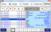
IF I come back to LOCALIZE, I find the RIGHT hand pane CS , has SALEM @ 102 PPM, and the left hand pane, "Design" has Unknown, with a number.
So, now I reset the right hand pane, to NAD 83, 2011, Arkansas South
And, the Left Hand Pane to Salem.... and I cannot find Salem AR to select.. it's not available.
So, not knowing how to proceed, I have in the past, deleted all design points, and all traces of localize, and started over... Then, I run into the problems above....

But, I can go back, and Select "Salem AR @ 102 ppm" for the right hand pane, but not the left hand pane.

In my thinking, "Salem AR @ 102 PPM" should never show up, on the right hand pane... because ALL localizations, should be from some foundational projection, TO some local system. To localized FROM "Salem AR @ 102 PPM" to some other system, puts two localizations into the LS, the first one being from SPC, to "Salem AR @ 102 PPM", then from "Salem AR @ 102 PPM" to ANOTHER system. I feel that this 2 tier system is NOT the intent of the system... or is it?

It seems to me, that ALL localizations, should be 1 tier localizations. Maybe that's not true.

So, partially, we are dealing with my ignorance, of what works, and what does not, and the mechanisms used to address the knowns, and unknowns, in the LS.

I have a basic understanding of projections... but not an extensive one.

Thank you,

N
 

Matt Johnson

Well-Known Member
5PLS
Nate, localization will work with any base grid system including defined SPCS and custom grid systems. On the design side you must have an unknown or local system. "SALEM @ 102 PPM" must have been a grid system. Did you use Adjust Grid to Ground & Rename to create it?
 

Nate The Surveyor

Well-Known Member
Yes I did. Maybe I am not understanding the proper mechanism to load, and work with a previous grid to ground. I want to load the previous perimeters, and look at it, and (Sometimes) modify it, and re save it. (Usually same name).
N
 

Matt Johnson

Well-Known Member
5PLS
Just use the Adjust Grid-to-Ground & Rename option again for that same CS. You can then view and modify the parameters.
 

Shawn Billings

Shawn Billings
5PLS
Yes I did. Maybe I am not understanding the proper mechanism to load, and work with a previous grid to ground. I want to load the previous perimeters, and look at it, and (Sometimes) modify it, and re save it. (Usually same name).
N

Nate, I would recommend this process for your future surveys:

Before heading to the field, Create New Project
After creating project, go directly to Localize and Set State Plane on the right and any unknown system on the left. Press Save and name the resulting localization with new meaningful name.
Set a page with this new coordinate system.
Import points into this new coordinate system.
In the field, collect points that are from your local system.
Go into localize, set State Plane on the right and new local system name on the left.
Make association(s) and save.
Repeat as desired. You can add new associations and resave as many times as you wish.
 
Top