T3NR Elevation Bust Problem: Calling All Thinkers

avoidthelloyd

Active Member
Friends, I can start my base on a known coordinate and then stake out to my base within a few tenths of it on fairly level ground and I'm getting ±0.35' bust.

Here's the situation and conditions and you tell me what you think is going on...
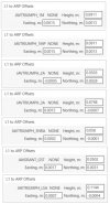
  • It's a new T3NR base and the only change in my setup and equipment. My T3 was in the shop.
  • I've checked this way on the last three projects with the same result and one is an existing project I've been to 4 other times in the past year with no problems.
  • The position I report is ±0.35' too low. It says Fill.
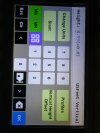
  • I measure the base height and rod heights carefully.
  • The Ant. Height on my LS+ is matching the physical rod height.
  • The same error on all my other control points in the project (it's consistent).
  • Confirmed no vertical offsets are applied to the base. It is 0'. I've never used this feature.
  • Project settings are what I always use (NAVD88) and the geoid is the same as always.
What would you check??? I will have my regular T3 base back sometime this week and will run it again next week and see if it results in the same error. I'd appreciate your thoughts.
 

avoidthelloyd

Active Member
Not sure what you are asking, but I always just measure the slant from monument to the appropriate spot on the bottom of the base and the LS. I don’t have any fixed rods. Thanks.
 

ken larson

Active Member
There is a spot to enter a vertical offset to your measurement.
 

Attachments

  • 17096922726061024242716208497179.jpg
    17096922726061024242716208497179.jpg
    1.5 MB · Views: 40

Steve Hankins

Active Member
5PLS
Yeah. I noted that mine has always been at 0 feet. I doubled checked it too. Thanks.
Just a guess. From "Home" screen, tap" Setup", then tap "General", then tap "Antenna". Is it possible under the "Antenna" screen "Measured Height" is set to something other than 0.0 ft., or is there a "Vertical Height Offset" in that screen set to something other than 0.0 ft. Also check under "Profiles" and see if it may be using a Profile that is introducing the 0.35 error.
 

Nate The Surveyor

Well-Known Member
I do not know what the problem is. But I do know a solution.

Set both base and rover up on the SAME elevation. Maybe a board between 2 tripods, or a table, or such. Let em cook for 4-6 hrs.
Take back inside, and Post Process, and check RTK. You can set it to record several hundred RTK shots on it's own.
Throw it all into a spreadsheet.
NOW you can either derive PRECISE point of measurement for that reciever, or you can apply corrections to the VERTICAL offset.
And, of course, come back and share the results.
:)
Nate
 

avoidthelloyd

Active Member
Just a guess. From "Home" screen, tap" Setup", then tap "General", then tap "Antenna". Is it possible under the "Antenna" screen "Measured Height" is set to something other than 0.0 ft., or is there a "Vertical Height Offset" in that screen set to something other than 0.0 ft. Also check under "Profiles" and see if it may be using a Profile that is introducing the 0.35 error.
Just checked and the Antenna Height is 5.5' which matches the measurement of my rod. I change this from the Collect screen as I need to correspond with my physical rod reading. The Vertical Height Offset is set to 0.0 ft which I have confirmed and even let Javad login with Rams the other day and they checked it too. As I noted, I have never even used this feature at all. Vertical offset in the LS+ is not the issue. Thanks.
 

avoidthelloyd

Active Member
I do not know what the problem is. But I do know a solution.

Set both base and rover up on the SAME elevation. Maybe a board between 2 tripods, or a table, or such. Let em cook for 4-6 hrs.
Take back inside, and Post Process, and check RTK. You can set it to record several hundred RTK shots on it's own.
Throw it all into a spreadsheet.
NOW you can either derive PRECISE point of measurement for that reciever, or you can apply corrections to the VERTICAL offset.
And, of course, come back and share the results.
:)
Nate
I've used that function on the LS when I ran outta radio. It was great. That would work and would show if I have a setting off, but right now, I don't feel I need to spend the time doing that to notice a 3 tenths bust.

As I mentioned, I've tied into ±8 control points with known coordinates on separate jobs with the same result. I'm concerned about the RTK elevations using the T3NR because I go to a lot of projects where control is already established and I will not be post processing, just checking into existing stuff. That's why it feels like some setting.

One of the projects I noticed this on was one where I set all the control with the T3 and I have been back to it with the T3 multiple other times and had no issues and I always check into the control. I do a LOT of elevation specific work and am very conscientious of my vertical measurements and settings. Usually, you only need to check into one other control point to see something is off. Every check has been consistently the same vertical error.

What I am going to do is take this T3NR and my T3 (It will be back this week) to the same jobs next week and I will fire them both up separately and see if the elevations check again with my T3. If my suspicions are correct, I will hit the control verticals with the T3 and be off with the T3NR.

I hope I am wrong and I really do have some setting wrong... cause I've done some other elevation sensitive work recently that I will have to revisit and make some calls...

I appreciate your input.
 

Matt Johnson

Well-Known Member
5PLS
It sounds like the antenna model for the base is not being applied. Are you using the Prerelease version of J-Field? Do you see the same error with RTPK?
 

Matt Johnson

Well-Known Member
5PLS
Have you tried checking that the T3NR has the most recent firmware installed? Also try clearing the NVRAM on the unit. Please check how RTPK compares too.
 

avoidthelloyd

Active Member
I compared the T3NR and T3 and they do appear to have a ±0.3' discrepancy in elevation during RTK using each as a base. After I DPOS the data, the T3NR data moved up 0.3' and the T3 data stayed within 0.05' and they both were setup on the same known coordinate.

I sent my report and the project to Support. I feel maybe there is a number in the programming for a measurement up to the antenna that is off or something?

We will see! Thanks.
 

John Rosco

Member
JAVAD GNSS
For all, here are the essential Antenna Phase Center (APC) 'offset information' for several JAVAD 'base' GNSS Receivers:-
 

Attachments

  • Javad Antenna Phase Center (APC) Offsets to ARP.jpg
    Javad Antenna Phase Center (APC) Offsets to ARP.jpg
    67.9 KB · Views: 33
Top