I did a demonstration last Friday and wanted to show how the verification process works. It's almost impossible to explain in the open because it all happens so quickly, so I took it to some difficult canopy. He's from Alabama and wanted to see the performance under pine canopy so we headed for the heaviest pine I had at hand. We collected data on two pine stumps. The first we shot twice. The second only once. All of the observations were sent to DPOS for base-rover processing. It's probably not good sales etiquette to visible show surprise when your product works, but I can't help it as I am continually impressed by the LS. Here are some pics I took with the LS.
First stump (canopy was not quite as bad as the second stump)

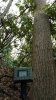
Second stump

Overhead view from Second stump

Forward view (to Northwest) from Second stump

The first stump was point L005 and L007
The second stump was point L006
I've attached the pdf of the project as well. The inverse from L005>L007 is dN -0.022', dE -0.092', dU -0.144'
The difference in RTK and PPK was:
L005 dN +0.008', dE +0.006', dU -0.009'
L007 dN -0.018', dE -0.041', dU -0.254'
L006 dN +0.020', dE -0.000', dU +0.017'